| Bathymetric | |
| Side Scan Sonar | |
| Shallow Seismic | |
| Oceanographic | |
| Pipe Route | |
| Site Investigation | |
Geometrics G858 Land Gradiometer
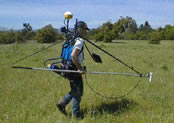
The G-858 MagMapper uses a graphical interface to make survey design and data acquisition quick and efficient. Various modes of operation allow the user to custom design a survey grid for their particular needs. The operator also has the ability to view his/her position on the grid and the current data profile during the survey. Sensitivity, resolution and recording rate of the cesium magnetometer are user selectable.
G-858 data acquisition offers either continuous or discrete station recording. The high sampling rate of the instrument in continuous mode allows the operator to survey an area at a fast walking pace. A wider search radius can be achieved by using a gradiometer configuration. As a result over-all costs are inherently lower while data quality remains high.
The G-858 is designed to interface easily with standard computers and peripherals. Geometrics encourages clients to provide their own processing computer hardware. Upon the client's request Geometrics will provide a complete and fully integrated processing station at a nominal price.
See more equipment.
To request a call for further information click here.